Collision Records — Safe Crossings Locations#
Open data, living document. You are welcome to use and share this data, but please link back to this page rather than copying it. This report is regularly updated with corrections, new evidence, and clarifications — copied data will quickly become outdated.
On this page#
- Locations under consideration
- Summary
- Across all locations
- How this connects to the survey findings
- How crossing decisions are made
Recorded injury collisions at and near the locations under consideration in the Safe Crossings work. The data is drawn from validated police records via CrashMap, which publishes Department for Transport STATS19 data. No fatalities were recorded in this dataset.
Locations under consideration#
The following locations from the Safe Crossings work now have collision records that support their case:
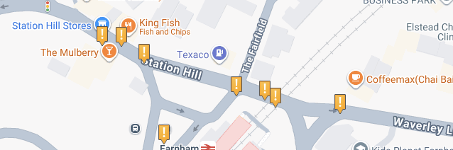
- Farnham Station / Station Hill — three collisions including two pedestrian injuries; all with no crossing within 50m; a cluster at effectively the same point
- Castle Street by Lowndes Passage / Park Row — pedestrian hit while crossing informally (Jun 2022); motorcycle collision (Feb 2023)
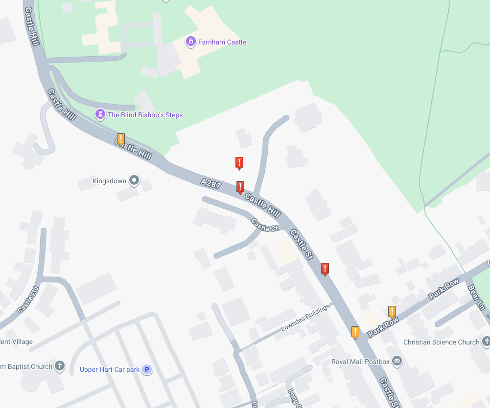
- Castle Hill / Old Park Lane — three collisions including two serious injuries, on bends with no crossing
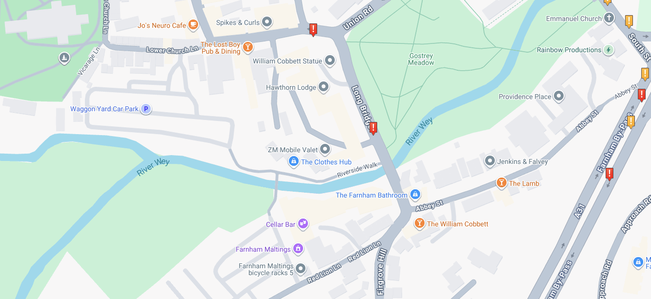
- Longbridge — serious pedestrian injury (Nov 2023), pedestrian walking in carriageway with no crossing available
A note on terminology: police collision records classify every injured person as a “casualty,” regardless of severity — a term that can sound more alarming than the injuries warrant. Throughout this page we use “people injured” instead. Severity is classified as serious (requiring hospital admission) or slight (any other injury requiring medical attention). “Collision” is the standard term used in official road safety data, replacing the older term “accident.”
Summary#
| Collisions recorded | 13 |
| People injured | 17 |
| Serious injuries | 5 |
| Slight injuries | 12 |
| Pedestrians injured | 4 (1 serious, 3 slight) |
| Cyclists injured | 1 (serious) |
| Locations with no crossing within 50m | 11 of 13 |
These figures represent a subset of the most relevant collision data for the locations under consideration. Additional collisions may have occurred on adjacent roads not covered here. The data should not be treated as a complete record for each area.
The 50-metre threshold is not our choice — it is the standard classification used in police collision records (STATS19). Officers record whether a physical crossing facility exists within 50 metres of the collision site; no finer distance is recorded.
Farnham Station area (B3001)
Three injury collisions were recorded on Station Hill near Farnham Station between September 2021 and March 2023. All three occurred on the B3001 within approximately 25 metres of each other, and all at locations with no physical crossing facility within 50 metres.
| Date | Location | Severity | People injured | Crossing facility | Key detail |
|---|---|---|---|---|---|
| Sep 2021 | Station Hill | Slight | 1 | None within 50m | Car hit pedestrian crossing informally; masked by parked vehicle; darkness |
| Dec 2022 | Station Hill | Slight | 1 | None within 50m | Car turning right hit vehicle slowing ahead |
| Mar 2023 | Station Hill | Slight | 1 | None within 50m | Car turning right hit pedestrian walking in carriageway |
Pedestrians crossing where no crossing exists#
Two of the three collisions involved pedestrians injured while crossing or walking in the carriageway. In both cases the pedestrian was recorded as being in the road informally — there is no designated crossing at this location.
September 2021: A pedestrian was hit while crossing from the nearside, recorded as “masked by parked or stationary vehicle.” The collision occurred in darkness. This is a pattern directly relevant to crossing assessments: parked vehicles reducing visibility for both drivers and pedestrians attempting to cross.
March 2023: A pedestrian walking in the centre of the carriageway was hit by a car turning right. The pedestrian was facing traffic.
The third collision (December 2022) involved a car turning right that struck another vehicle slowing or stopping ahead.
A cluster at a single location#
The grid references for all three collisions place them within a very short stretch of Station Hill. Three recorded injury collisions at effectively the same point — two involving pedestrians with no crossing available — represents a collision cluster that would be relevant to any crossing assessment at this location.
Castle Street, Castle Hill & surrounding roads (A287)
Between July 2020 and November 2023, ten injury collisions were recorded on or near the A287 corridor — from lower Castle Street through Castle Hill and Folly Hill, with additional incidents at Firgrove Hill and Longbridge.
| Date | Location | Severity | People injured | Crossing facility | Key detail |
|---|---|---|---|---|---|
| Jul 2020 | Castle Hill | Slight | 3 | None within 50m | 3 cars; one hit a parked vehicle |
| Oct 2020 | Firgrove Hill | Slight | 1 | Pelican crossing present | Single car hit wall; driver over 75 |
| Apr 2021 | Firgrove Hill | Serious | 1 | Signal junction | Car turning right hit cyclist |
| Sep 2021 | Castle Hill | Serious | 1 | None within 50m | 2 vans; darkness, rain, wet road |
| Jan 2022 | Castle Hill | Serious | 1 | None within 50m | Single car; darkness, frost/ice, 00:45 |
| Jun 2022 | Castle Street / Park Row | Slight | 1 | None within 50m | Car turning right hit pedestrian crossing the road |
| Sep 2022 | Castle Street (lower) | Slight | 2 | None within 50m | Car passing another on nearside; rain |
| Feb 2023 | Park Row | Slight | 1 | None within 50m | Car hit electric motorcycle waiting in traffic |
| Jul 2023 | Folly Hill | Serious | 2 | None within 50m | Van and car head-on; 40mph zone |
| Nov 2023 | Longbridge | Serious | 1 | None within 50m | Car hit pedestrian walking in carriageway |
Recent incident#
Not yet in validated data. On 18 August 2026 at approximately 18:00, a collision occurred on Castle Street outside the Nelson Arms. The vehicle was travelling at very low speed — the driver made an emergency stop and collided. No casualties were reported and only minimal damage was visible on the vehicle. This incident is not yet in the validated STATS19 dataset but is noted here as it occurred on the same stretch of road where no crossing facility exists.
No crossing, no safe way across#
Eight of the ten collisions on this corridor occurred where there is no physical crossing facility within 50 metres. Both injured pedestrians were at locations with no crossing:
Park Row exit (June 2022): A pedestrian was hit by a car turning right. The injured person was recorded as “in carriageway, crossing elsewhere” — meaning they were crossing the road at an informal point because no designated crossing exists. This is exactly the location survey respondents identify as the most dangerous stretch of Castle Street.
Longbridge (November 2023): A pedestrian was hit while walking in the centre of the carriageway with their back to traffic. The pedestrian sustained serious injuries. A crossing at Longbridge has been under consideration as part of the Safe Crossings work.
Castle Hill cluster#
Three collisions occurred within a 200-metre stretch of Castle Hill — two resulting in serious injuries. The grid references place them near the bend between Castle Street and Castle Hill, the same area survey respondents consistently identify as the worst stretch for speed and visibility. Two of the three happened in darkness, one on ice.
Firgrove Hill — where a crossing exists#
The two Firgrove Hill incidents are notable because a signal-controlled crossing is present. One collision (slight, single vehicle) involved an elderly driver. The other — a car turning right that hit a cyclist, causing serious injury — occurred at the traffic signal junction itself. The presence of a crossing does not eliminate risk, but the pattern elsewhere is clear: locations without crossings have more collisions and more pedestrian injuries.
Across all locations#
Pedestrians and cyclists bear the cost#
Of the 17 people injured across all recorded collisions, four were pedestrians and one was a cyclist. All four injured pedestrians were at locations where there was no crossing within 50 metres. The cyclist was seriously injured at a junction. These are the road users that crossings and traffic calming are designed to protect.
How this connects to the survey findings#
The Castle Street & Castle Hill survey asked residents and visitors how they experience this corridor. The collision data directly supports what respondents reported:
| Survey finding | Collision evidence |
|---|---|
| 64% rated crossing as difficult; upper Castle Street near Park Row identified as worst | Pedestrian hit at Park Row while crossing informally — no crossing exists |
| Castle Hill from Masonic centre to cricket club flagged for speed and poor visibility | 3 collisions on Castle Hill, 2 serious, including darkness and adverse conditions |
| 79% selected safer crossings as a top priority | 8 of 10 collisions at locations with no crossing within 50m |
| Longbridge identified as needing a crossing | Serious pedestrian injury at Longbridge — pedestrian walking in carriageway |
How crossing decisions are made#
Decisions about pedestrian crossings are not based on collision numbers alone. Highway authorities consider a range of factors when assessing whether a crossing or other highway intervention is appropriate.
The Department for Transport’s Local Transport Note 1/95 (LTN 1/95) established a widely used assessment framework for pedestrian crossings. Although the guidance has now been withdrawn, its assessment approach illustrates the factors traditionally considered by highway authorities. These include:
- Pedestrian and vehicle movements — including the number and type of pedestrians using the route, traffic volumes and vehicle speeds.
- Difficulty crossing — including available gaps in traffic, waiting times and the time different groups of pedestrians need to cross safely.
- Collision history — recorded injury collisions at and around the proposed location, including their circumstances, severity and whether a pattern exists.
- Site characteristics — including road width, visibility, nearby junctions, lighting, bus stops and other physical constraints.
- Vulnerable road users — including children, older people and disabled pedestrians.
- Existing provision and alternatives — including nearby crossings, refuge islands and other measures that could improve pedestrian safety.
LTN 1/95 emphasises that the decision should be a balanced judgement based on the available evidence rather than any single numerical threshold. It also recognises that difficult road conditions can suppress pedestrian demand — meaning a low pedestrian count does not necessarily demonstrate that a crossing is unnecessary.
Surrey County Council is the highway authority responsible for most local roads in Surrey, including measures such as pedestrian crossings. Its Healthy Streets guidance states that streets should be easy to cross and that well-designed crossings can also contribute to lower traffic speeds.
Collision history therefore matters, but it does not automatically determine the solution. Where collisions occur, engineers should consider their circumstances and causes. Depending on the evidence, the appropriate response might be a formal crossing, traffic calming, improved visibility, another form of pedestrian facility, or a combination of measures.
Recorded collisions are not, by themselves, a case for installing a crossing. They are evidence that should form part of the wider assessment of pedestrian safety, crossing difficulty and the appropriate highway response.
Collision data sourced from CrashMap (validated STATS19 police records, Department for Transport). Assessment guidance: LTN 1/95 (DfT). Surrey County Council Healthy Streets crossing guidance. This page presents publicly available data — Farnham Voice does not make crossing decisions.