Heritage Considerations for Safe Crossings#
Open data, living document. You are welcome to use and share this data, but please link back to this page rather than copying it. This report is regularly updated with corrections, new evidence, and clarifications — copied data will quickly become outdated.
On this page#
This report summarises the heritage considerations relevant to each proposed crossing location in the Safe Crossings initiative. It is intended to be read alongside the location-specific assessments and draws on guidance from Historic England and Surrey County Council.
How to use this report#
Each crossing location is assessed against the heritage constraints that apply to it. Where a location sits within a conservation area, near a listed building, or on a scheduled monument, the relevant designations and their practical implications are explained.
Summary#
| Location | Original ask | Heritage status | Heritage position | Key constraint |
|---|---|---|---|---|
| Station Crossing | Crossing on existing raised table | None (modern fabric) | Raised table preferred; Belisha possible | No heritage constraints identified |
| Longbridge | Speed calming table + Belisha beacon | None (modern fabric) | Raised table preferred; Belisha possible (space permitting) | Pavement width for power cabinets |
| Lowndes Passage | Raised table; granite setts or rumble strips as fallback | Conservation area | Raised table preferred; Belisha unlikely | Visual clutter, possible archaeology |
| West Street | Belisha beacon; rumble strips as fallback | Conservation area + curtilage listed | Raised table preferred; Belisha unlikely | Curtilage-listed wall, narrow pavement |
| Old Park Lane | Speed calming, tables or rumble strips, electronic signage | Conservation area + scheduled monument | No safe crossing point identified; traffic calming and signage (SAMs) on approaches | Scheduled monument consent required for nearby works |
General Heritage Position#
The following principles apply across all proposed crossing locations:
Belisha beacons are unlikely to be acceptable. Traditional zebra crossings require Belisha beacon poles, underground power cabling, and electrical cabinets on the pavement. These introduce visual clutter that is generally incompatible with conservation areas. Historic England’s Streets for All guidance identifies beacons, guardrails, and zig-zag markings as sources of clutter that can harm the character of historic streets.
Raised tables and low-noise crossings are preferred. Where a crossing is appropriate, a raised table constructed level with the adjacent pavement and using matching materials is the least visually intrusive option. These require no power supply, no poles, and no electrical cabinets. Surrey CC’s Healthy Streets for Surrey guidance supports raised tables at mid-link crossings, constructed to read as “an extension of pedestrian space.”
No historic fabric on Longbridge or at Station Crossing. These two locations have modern pavement surfaces and are unlikely to raise heritage concerns from the conservation team.
Heritage advice is advisory, not binding. Conservation officers and Historic England provide guidance, but local councils are not obliged to follow it. Heritage considerations carry weight in planning decisions but can be balanced against other factors such as pedestrian safety.
Most crossing types do not require planning permission. Highway works carried out by or on behalf of the highway authority are generally permitted development. However, works affecting scheduled monuments require Scheduled Monument Consent, and works affecting the setting of listed buildings may require listed building consent.
Key terms#
Conservation area — An area designated by the local authority for its special architectural or historic interest. Any works within it should preserve or enhance the area’s character.
Curtilage listed (“listed by osmosis”) — Under the Planning (Listed Buildings and Conservation Areas) Act 1990, any pre-1948 structure within the boundary of a listed building is treated as part of that listing. Altering it without listed building consent is a criminal offence.
Scheduled monument — A nationally important archaeological site protected under the Ancient Monuments and Archaeological Areas Act 1979. Written consent from the Secretary of State (via Historic England) is required before most works can begin. This is the highest level of heritage protection in the UK.
Historic fabric — The original physical material of a historic place: paving, kerb stones, setts, boundary walls, and drainage features. Retaining historic fabric is a core conservation principle.
Footpath designations (FP86, FP92, FP95 etc.) — Public footpaths recorded on the Surrey CC Definitive Map. Each number is unique within a parish. The routes and their legal status can only be changed by formal legal order.
Relevant guidance#
- Historic England, Streets for All (HEAG149, 2018) — National guidance on highway and public realm works in historic places.
- Historic England, Streets for All: South East — Regional supplement with area-specific advice.
- Surrey CC, Healthy Streets for Surrey — County design standards for highways, including street furniture, raised tables, and pavement widths.
- Historic England, Pre-Application Advisory Service — Free initial advice on proposals affecting designated heritage assets. Available before formal applications are submitted.
Crossing Locations#
Farnham Station — Station Hill Crossing
Heritage status: No historic pavement fabric. Modern surfaces throughout.
Assessment: This location is unlikely to raise heritage concerns. There is no historic fabric in the pavement, and the station area has been substantially modernised.
Standard highway design considerations apply (pavement width, lighting, drainage) but no heritage-specific constraints have been identified.
Castle Street — Lowndes Passage (by the Masonic Lodge)
Heritage status: Conservation area.
Preferred approach: A low-noise raised crossing or rumble strips are most likely to be acceptable from a heritage perspective.
Key considerations:
- A raised table without beacon poles or road markings would introduce minimal visual clutter. Because there is no power requirement, no electrical cabinets or cabling would be needed on the pavement.
- A full zebra crossing with Belisha beacons is unlikely to be recommended by the heritage team. The beacon poles and zig-zag markings would add visual clutter when looking up or down Castle Street, harming the character of the conservation area.
- There may be archaeological considerations beneath the road surface. This has not been formally assessed and may need investigation if any excavation (for power cabling or foundations) is proposed.
- Crossings near residential properties may attract concerns about vehicle vibration from raised surfaces. This has not been widely raised by residents to date, but is a known consideration for raised tables in residential streets.
- Surrey CC’s Healthy Streets guidance requires street furniture to be painted black in town centre conservation areas.
Outstanding: Engagement with the Surrey CC Highways team is in progress to understand any additional constraints they may raise.
Castle Hill — Old Park Lane
Heritage status: Conservation area. Adjacent to a scheduled monument (Farnham Castle grounds — shown as the blue and white boundary line on heritage mapping). This is the highest level of heritage legislation in the UK.
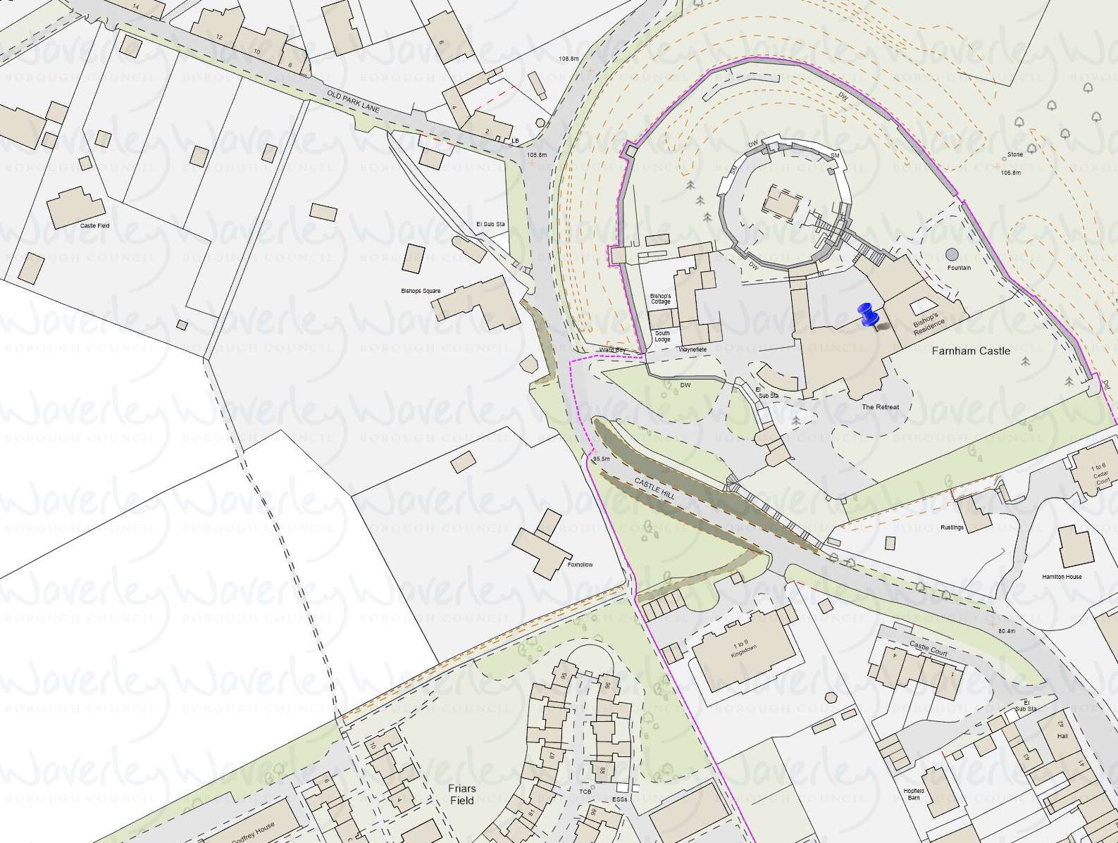
This location involves two distinct considerations: a safe crossing point, and safe pedestrian access to the town centre from Old Park Lane.
Safe crossing#
There is no clear safe location for a traditional crossing on Castle Hill near Old Park Lane. The steps by Old Park Lane are not safe and should not be encouraged as a crossing point, as this would increase the risk of accidents on the bend.
However, traffic calming measures on the approach from Folly Hill could help reduce vehicle speeds before the bend, improving safety without requiring a formal crossing.
Three footpath exits onto Castle Hill have been assessed:
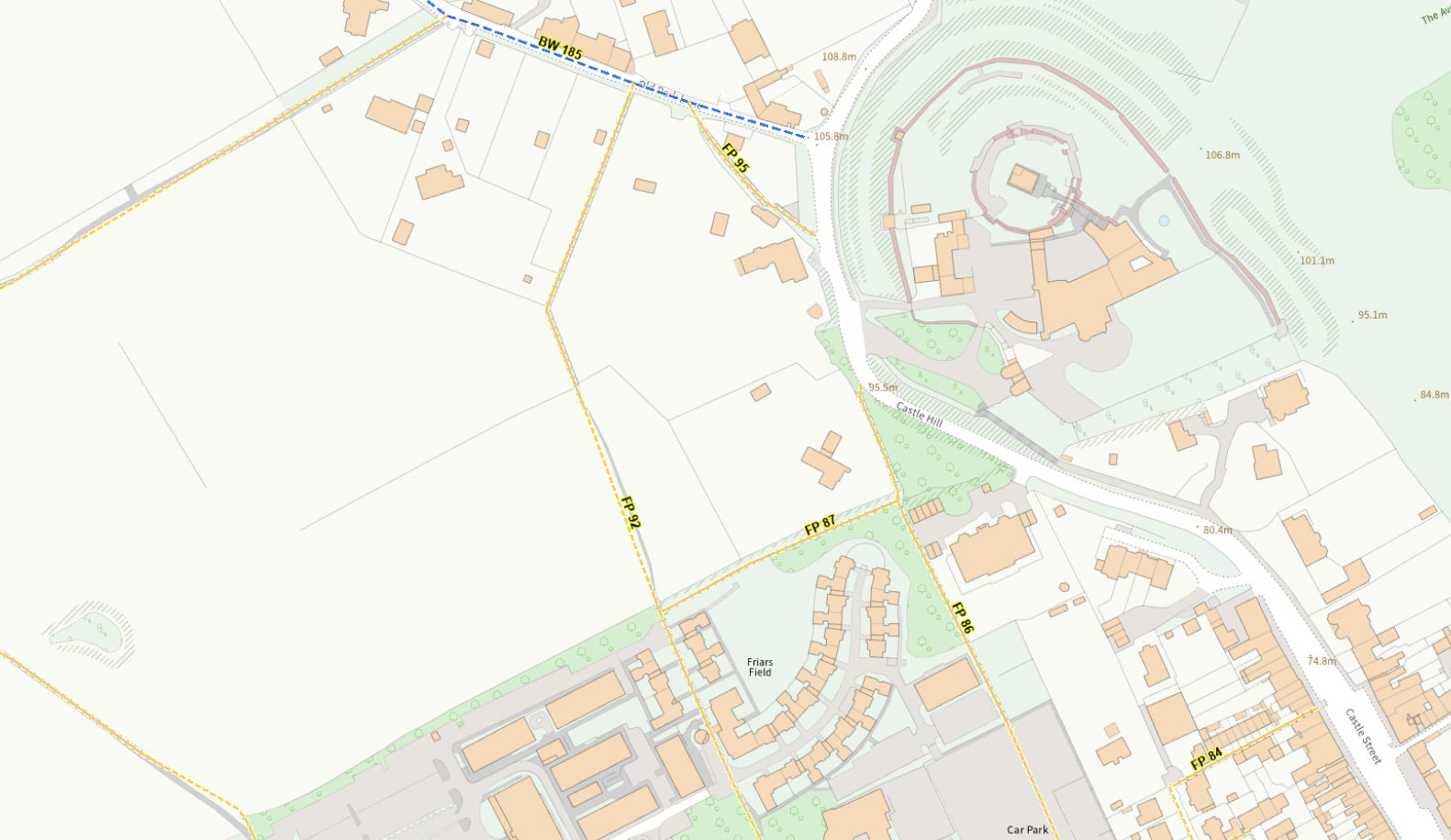
Footpath FP95 (lower path, near the scheduled monument boundary) There is no clear direct path to the opposite side of the road, and part of this route falls within the scheduled monument. Any works here would require Scheduled Monument Consent from the Secretary of State, obtained through Historic England. This is already being explored with Historic England and will be updated in due course.
Footpath FP86 (Fox Hollow exit) This crosses directly to the castle pathway and entrance and is the least constrained of the three options from a heritage perspective. However, visibility from the castle side of the road is a significant risk — vehicles approaching from Castle Hill around the bend may not be visible to pedestrians until very late. There is also no direct pedestrian connection between Fox Hollow and the upper pathway or the exit from Farnham Castle, which limits its usefulness for some journeys.
Kingsdown entrance area (alternative) An alternative option would be to create a pavement on the Kingsdown development side of Castle Hill, enabling a crossing where residents currently cross informally just below the Kingsdown entrance. This would provide a more natural crossing point with better visibility than the Fox Hollow exit. However, this does not directly solve pedestrian access from Old Park Lane itself.
Footpath FP92 (safest route to the town centre) This is currently the safest walking route from Old Park Lane to the town centre. However, in wet weather the path can become difficult to walk due to the unpaved surface.
Safe crossing provision in the Old Park Lane area requires further exploration. None of the options assessed so far fully resolves both the crossing and the direct access from Old Park Lane — each addresses part of the problem but not all of it.
Pedestrian access improvements#
The practical suggestions for improving pedestrian safety from Old Park Lane are:
- Underfoot paving along FP92 — a simple surface improvement along the country stretch of this footpath to make it usable in all seasons.
- A pavement connection from FP95 to Fox Hollow (FP86) — linking the lower footpath to the best crossing point. This would need to be assessed against the scheduled monument boundary.
- A pavement along the Kingsdown side of Castle Hill — enabling a crossing near the Kingsdown entrance where residents already cross informally.
Pedestrian access — now a separate workstream#
The assessment of Old Park Lane has shown that safe crossing and safe pedestrian access are two related but distinct problems. Improving FP86 and FP92 to provide reliable year-round walking routes to the town centre has become its own workstream. See Pedestrian Access — Old Park Lane for the full detail, including requests made to Surrey County Council.
Historic England engagement#
Historic England offers a pre-application advisory service for works affecting scheduled monuments and other designated assets. The first initial round of advice is free.
Farnham Voice has already engaged Historic England’s pre-application advisory service. This process is underway and will be updated as guidance is received.
Historic England has also published Streets for All guidance, which is directly relevant to any crossing or traffic calming proposals in this area.
Outstanding: Pre-application advice from Historic England is being sought for works near the scheduled monument boundary.
Longbridge — North of the Bridge
Heritage status: No historic pavement fabric. Modern surfaces throughout.
Assessment: This location is unlikely to raise heritage concerns. The conservation team has not identified constraints related to historic fabric or the setting of listed buildings.
The only potential issue is clutter and space. If a crossing type is chosen that requires lighting with mains power, the associated electrical cabinets could reduce available pavement width. Surrey CC’s Healthy Streets guidance requires a minimum 1.5 metres clear passage around any street furniture, and a general minimum pavement width of 2 metres.
West Street — Potters Gate
Heritage status: Conservation area. Adjacent to a curtilage-listed structure.
Preferred approach: A raised crossing or pedestrian crossing is most likely to be acceptable here.
Key considerations:
- The Potters Gate boundary includes ironstone surfaces which are not historic fabric and would not be impacted by crossing works.
- The building with the white boundary wall is curtilage listed — it is a pre-1948 structure within the boundary of a listed building, and is therefore treated as listed itself under the Planning Act 1990. Any works placed against or attached to this wall could potentially cause damage and would require listed building consent.
- The pavement may be too narrow at certain points to accommodate crossing infrastructure while maintaining the required 1.5m clear passage. This will need to be measured on site.
- A shop in the vicinity has planning permission to become a residential dwelling, which may change the character of the immediate area and the nature of pedestrian traffic.
- Surrey CC guidance requires all street furniture in this area to be painted black where possible.
This report is a working draft and will be updated as engagement with Historic England and Surrey County Council progresses.